作者:托福听力 严若涵 周菲菲
1. Volcano 火山
Volcanoes are formed when magma from within the Earth's upper mantle works its way to the surface. There are three main types of volcano - composite or strato, shield and dome.
火山是在岩浆从地幔上部喷到地表的过程中形成的。火山主要分为三类:复合火山、盾状火山和穹状火山。
Most of the world's volcanoes occur at the boundaries of the tectonic plates such as the so-called "Ring of Fire" in the Pacific Ocean. However, some occur not at the edges, but in the middle of a continental or oceanic plate like Hawaii islands.
世界上大部分的火山都是在这些地壳板块的交界处喷发的,比如太平洋的“火环区”。但是有一些火山不在边缘处喷发,而是在一个大洲或海洋板块的中央喷发,比如夏威夷群岛。

2. Glacier 冰川
A glacier is a huge mass of ice that moves slowly over land. It is formed from compacted layers of snow. Basically, glaciers fall into two groups: alpine glaciers and ice sheets.
冰川是在大陆上缓慢移动的大量冰块,由一层层雪堆积压缩形成。通常分为两种:高山冰川和大陆冰盖。
It’s really no secret that glaciers flow because of gravity. Basically, it happens in two ways, basal slip and deformation.
众所周知,受重力影响冰川会出现位移。位移的方式有两种,基面滑移和变形。

3. Basin 盆地
A basin is a depression, or dip, in the Earth’s surface. Basins are shaped like bowls, with sides higher than the bottom. They can be oval or circular in shape, similar to a sink or tub you might have in your own bathroom. Some are filled with water. Others are empty.
盆地,盆地是盆状地形,主要特征是四周高(山脉或其它山地隆起带)、中部低(平原和丘陵),是世界五大基本陆地地形之一。
The formation of basin: Basins are formed by forces above the ground (like erosion) or below the ground (like earthquakes). They can be created over thousands of years or almost overnight.
盆地的形成主要是由于地表外力比如风力,雨水等破坏作用而形成,或者是由于地壳运动作用而形成。
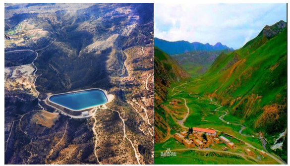
4. Plain 平原
A Plain is an area of lowland, either level or undulating. It seldom rises more than a few hundred feet above the sea level.
平原指的是平坦或者起伏的低地。平原比海平面要高,但高出的部分不会超过几百英尺。
Plains are usually categorized into three types -- structural plain, depositional plain and erosional plain -- based on their mechanism of formation.
根据不同的成因,平原可分为构造平原、冲击平原和侵蚀平原。

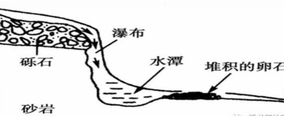
5. Waterfall 瀑布
A waterfall is an area where water flows over a vertical drop or a series of steep drops in the course of a stream or river.
瀑布,指河流或溪水经过河床纵断面的陡坡时,近乎垂直地倾泻而下的水流景象。
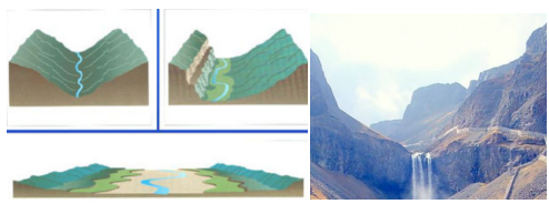
6. Valley 山谷
A valley is a low area between hills or mountains typically with a river running through it. There are three main types of valleys, the V-shaped valley, the flat floored valley and the U-shaped valley.
山谷是山川间的低地,其间常有小河流过。山谷可分为三类:V型、平底型和U型。
Valleys generally contain fertile land that are suitable for farming and thus ideal places for ancient civilization to flourish. Also, the mining resources are abundant in some valleys.
山谷通常有肥沃的土壤,是古文明的理想发祥地。有的山谷还蕴含丰富的矿产资源。
7. Oasis 绿洲
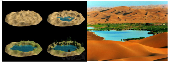
An oasis refers to an area that is fertile and has water within an area that is arid. Life is harsh in the desert, but the presence of an oasis makes it bearable.
绿洲指的是在干旱贫瘠地区(如沙漠/荒漠)出现的小块水源丰富土壤肥沃带有植被的孤立地带。
The formation of oasis: 1)It is formed when faulting and climatic conditions create a depression in an arid region. When the depression deepens enough to reach the water table, the underground water comes into the surface to form an oasis. 2) Surface rivers, rainstorms, and other natural factors also lead to the formation of oases.
绿洲的形成与断层或气候条件导致的凹陷有关,当凹陷深到接近地下水的位置时,地下水就会顺着裂缝流出来;或者由于河流,雨水,雪水等渗入地下,与地下水汇合流到沙漠的低洼地带。
8. Butte /bjuːt/ 小丘
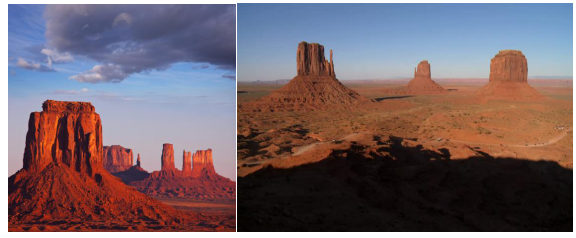
An isolated hill or mountain with steep sides and a flat top rising abruptly above the surrounding land.
顶部平坦的小丘,高地。
The formation process of butte:Buttes are created as streams slowly cut through a mesa or plateau.The hard top layers of buttes, called caprock, resist weathering and erosion. As a result, the formations stay about the same height as the original plateau or mesa. Weathering and erosion slowly erode the softer rock surrounding the caprock. Caprock protects the more vulnerable rock beneath it. Buttes slowly become slender spires.
水流经过把高原切割。高原表面覆盖岩层较坚硬能抵抗风化和侵蚀,所以高度还是和原来保持一致。后来随着风化和侵蚀作用把覆盖岩层周边较软的岩石侵蚀,就慢慢形成了被切割和外力因素造成的成独立的表面平展的小山丘。
9. Dune 沙丘
Dunes are large masses of wind-blown sand, and are most common in deserted environments and also near beaches. There are five basic types of dunes: crescentic, linear, star, dome, and parabolic.
沙丘,是指一种在风力作用下沙粒堆积的地貌,常见于沙漠地带和海边。沙丘分为五类:新月型、线形、星形、穹状、抛物线型。
Since sand dunes contain other types of particles such as clay and silt, a layer that water couldn’t penetrate forms whenever it is raining. Once this pan formed, further run-off collected, and lakes can be formed int he desert.
沙丘中含有其他种类的粒子,比如黏土和泥沙。降雨的时候,会形成不透水层。这种凹地一旦形成,进一步收集径流,从而形成沙漠湖泊。

10. Plateau 高原
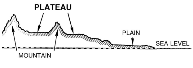
Extensive area of flat upland usually bounded by an escarpment (i.e., steep slope) on all sides but sometimes enclosed by mountains.
是指海拔高度在500米以上的地区,地势相对平坦或者有一定起伏的广阔地区。如我国的青藏高原、云贵高原。
The formation of plateau: A plateau is formed by a process of geological uplift, either due to the collision of continental plates, pressure from magma below or the burial of land by volcanic lava and ash flows, resulting in a high, flat surface.
高原是由于大陆板块碰撞,来自地下的熔岩压力或者火山岩浆掩埋所导致的。
11. Canyon 峡谷
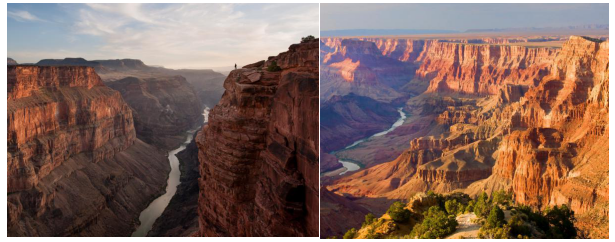
A canyon is a deep, narrow valley with steep sides and often with a stream flowing through it. “Canyon” comes from the Spanish word cañon, which means “tube” or “pipe.” The term “gorge” is often used to mean “canyon,” but a gorge is almost always steeper and narrower than a canyon.
峡谷是指谷坡陡峻、深度大于宽度的山谷,通常会有溪流流于其间。 gorge中文翻译也为峡谷,但是一般比canyon要更狭窄和陡峭。
The formation of canyon: The movement of rivers, the processes of weathering and erosion, and tectonic activity create canyons.
河流运动,风化和地壳运动都会造成峡谷的形成。
12. Strait 海峡
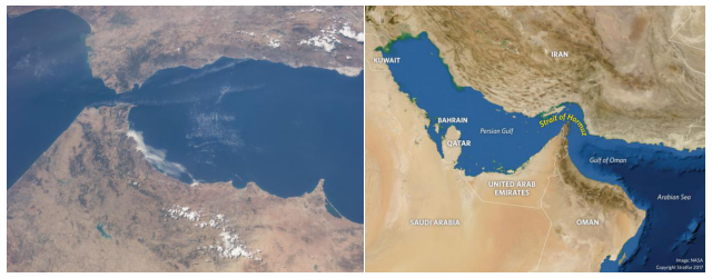
A strait is a naturally formed, narrow, typically navigable waterway that connects two larger bodies of water. Most commonly it is a channel of water that lies between two land masses. Some straits are not navigable, for example because they are too shallow, or because of an unnavigable reef or archipelago.
海峡是指两个水域之间的可航行的狭窄水上通道。但是也可能会因为水体过浅或者有大的暗礁或群岛导致不能通航。
The formation of strait:It may be formed by a fracture in an isthmus(地峡), a narrow body of land that connects two bodies of water or tectonic shifts. A strait can also be formed by a body of water overflowing land that has subsided or has been eroded.
海峡形成及类型:1)板块生长造成的裂谷发育,裂谷型海峡;2)板块碰撞形成;3)原始地形基础上,主要由于海水侵入、冰川侵蚀、河流侵蚀等作用形成的侵蚀型海峡。
13. Tributary 支流
A tributary is a freshwater stream that feeds into a larger stream or river. Tributaries do not flow directly into the ocean. It takes many tributary streams to form a river.
支流指的是融汇到更大的河流中的淡水小河。支流不会直接进入大海。河流通常由很多支流组成。
Tributaries are an integral component of river networks, serving as valuable links in the landscape for enhancing biodiversity. But projects like hydro-power dams may fragment river ecosystems by changing peak flow magnitude and rates.
支流是河流系统的重要组成部分,是提高所在地生态多样性的枢纽。但是诸如水电站的项目会破坏河流系统,因为高峰水流量和水流速度都会发生改变。

14. Bay 海湾
A bay is a body of water partially surrounded by land. It is usually smaller and less enclosed than a gulf.
海湾(bay)指被陆地部分环绕的水体,和gulf(海湾)相比,面积更小,更为开放。
Common pollutants in bay areas are nitrogen, phosphorous and sediment. To protect such areas, both efforts to reduce scattered source pollution and increase buffer zones of trees are required.
海湾常见的污染物包括氮、磷和沉积物。为了保护环境,即需要减少分散的污染源,也要增加林地缓冲带。

15. Gulf 海湾
A gulf is a portion of the ocean that penetrates land, an arm of an ocean, one may say. 海湾(gulf)是深入陆地的一部分海洋,也有人说它像海洋的一个手臂。
The Gulf of Mexico is the largest gulf in the world. It was formed approximately 300 million years ago when a seafloor sank. It is located on the coast of Mexico and The United States of America.
墨西哥湾是世界上的海湾。 三百万年前,海底发生塌陷,形成了海湾。墨西哥湾墨西哥和美国的海岸相邻。

16. Peninsula 半岛
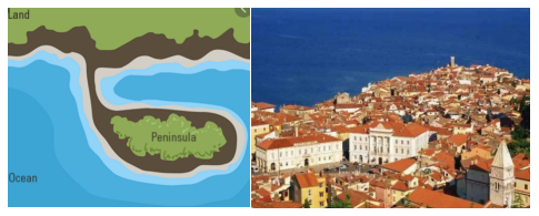
A peninsula is a piece of land that is almost entirely surrounded by water but is connected to the mainland on one side.
半岛指的是几乎被海洋包围,但是有一部分和大陆相连的一块地。
Europe could be seen as a peninsula from Eurasia. Within Europe, there are tons of peninsulas as well: Scandinavian, Jutland, Italian, Balkan and Iberian.
欧洲可视为欧亚大陆的一个半岛。在欧洲,还有很多小半岛,包括斯堪纳维亚半岛、日德兰半岛、意大利半岛、巴尔干半岛和伊比利亚半岛。
17. Archipelago 群岛
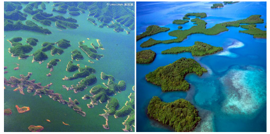
An archipelago is a group of islands closely scattered in a body of water. Usually, this body of water is the ocean, but it can also be a lake or river.
群岛,群集的岛屿类型。一般是指集合的岛屿群体,是彼此距离很近的许多岛屿的合称
The formation of archipelago: Archipelagos generally originate from volcanic activities associated with large magma eruptions. They can also be the result of erosion or soil deposition processes.
群岛是由于火山活动的熔岩喷发或者是外力因素(土壤沉积或侵蚀作用)而形成。
18. Atoll/lagoon 珊瑚环礁
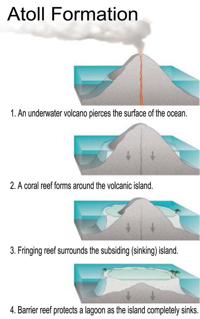
An atoll , sometimes called a coral atoll, is a ring-shaped coral reef including a coral rim that encircles a lagoon partially or completely.
环礁是海洋中呈环状分布的珊瑚礁,中间有封闭或半封闭的泻或礁湖。
The formation of atoll/lagoon:
19. Delta 三角洲
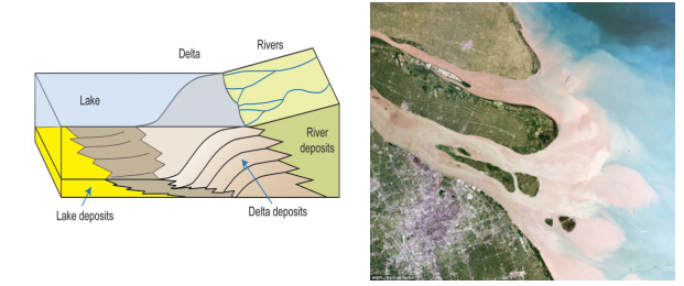
Deltas are wetlands that form as rivers empty their water and sediment into another body of water, such as an ocean, lake, or another river. Although very uncommon, deltas can also empty into land.
三角洲,即河口冲积平原。河口为河流终点,即河流注入海洋、湖泊或其他河流的地方。未流入湖泊的内流河称为无尾河,可以没有河口。
Delta formation process: 1)River have sufficient load; 2)velocity of river water is low; 3)subsidence in area of deposition.
三角洲的形成过程:河流携带大量泥沙,入海口地势较平缓,河流流速变缓,其所携带泥沙大量沉积逐渐形成冲击平原。
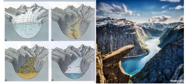
20. Fjord /fjɔrd/ 峡湾
Geologically, a fjord or fiord is a long, narrow inlet with steep sides or cliffs, created by a glacier.
峡湾是一种特殊形式的长而狭长的槽谷,为海侵后被淹没的冰川槽谷,是冰川槽谷的一种特殊形式
The formation process of fjord: A fjord is formed by the movement of a glacier that cuts rock formations, forming steep ridges or cliffs on each side of a valley. The valley fills with water from a nearby ocean or sea, leaving steep rock formations above water on either side.
峡湾是冰川与海洋共同作用的结果,数万年前巨大的冰川切割海岸边的大地,形成一道道槽谷,而当冰川消融后,海水倒灌进槽谷,便形成了峡湾
